- The Bom has issued a wide spread severe thunderstorm warning.
- For people in Hunter, Metropolitan, Illawarra, South Coast, Central Tablelands, Southern Tablelands, Central West Slopes and Plains and parts of Mid North Coast, North West Slopes and Plains, South West Slopes, Lower Western, Upper Western, Snowy Mountains and Northern Tablelands Forecast Districts.
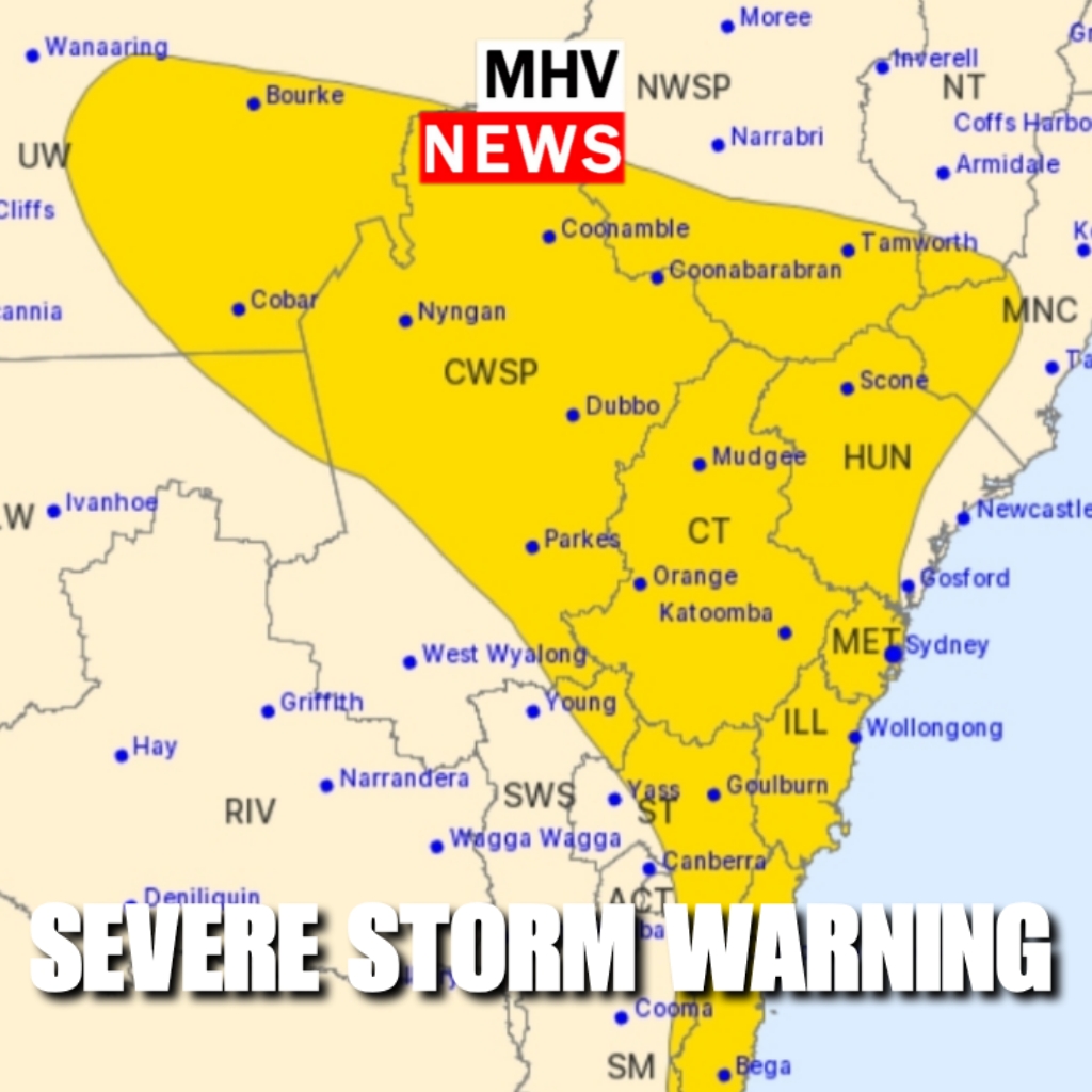
Severe thunderstorms are likely to produce damaging winds, heavy rainfall that may lead to flash flooding and large hailstones over the next several hours in the Hunter, Metropolitan, Illawarra, South Coast, Central Tablelands, Southern Tablelands, Central West Slopes and Plains and parts of the Mid North Coast, North West Slopes and Plains, South West Slopes, Lower Western, Upper Western, Snowy Mountains and Northern Tablelands districts. Locations which may be affected include Sydney, Wollongong, Nowra, Batemans Bay, Orange, Goulburn, Tamworth, Gunnedah, Dubbo, Parkes, Cobar and Bourke.
Severe thunderstorms are likely to produce intense rainfall that may lead to dangerous and life-threatening flash flooding over the next several hours in parts of the South Coast and Southern Tablelands districts. Locations which may be affected include Araluen.
– A 47KT (87km/h) wind gust was observed at Forbes around 11:00 AEDT.
– 34.6mm was recorded at Trunkey Ck on the Central Tablelands in the 60min to 14:00 AEDT.
– 50mm in 30min to about 15:15 AEDT at Nobbys Hill on the South Coast.
The State Emergency Service advises that people should:
- Move your car under cover or away from trees.
- Secure or put away loose items around your house, yard and balcony.
- Keep at least 8 metres away from fallen power lines or objects that may be energised, such as fences.
- Report fallen power lines to either Ausgrid (131 388), Endeavour Energy (131 003), Essential Energy (132 080) or Evoenergy (131 093) as shown on your power bill.
- Trees that have been damaged by fire are likely to be more unstable and more likely to fall.
- Keep clear of creeks and storm drains.
- Don’t walk, ride your bike or drive through flood water.
- If you are trapped by flash flooding, seek refuge in the highest available place and ring 000 if you need rescue.
- Be aware that run-off from rainfall in fire affected areas may behave differently and be more rapid. It may also contain debris such as ash, soil, trees and rocks.
- After bushfires, heavy rain and the loss of foliage can make the ground soft and heavy, leading to a greater chance of landslides.
- Unplug computers and appliances.
- Avoid using the phone during the storm.
- Stay indoors away from windows, and keep children and pets indoors as well.
- Stay vigilant and monitor conditions. Note that the landscape may have changed following bushfires.
- For emergency help in floods and storms, ring the SES (NSW and ACT) on 132 500.
The next warning is due to be issued by 6:40 pm.
If severe thunderstorms develop in Sydney Newcastle Wollongong or surrounding areas, a more detailed Severe Thunderstorm Warning will be issued to people in this area.
Warnings are also available through TV and Radio broadcasts, the Bureau’s website at www.bom.gov.au or call 1300 659 210. The Bureau and State Emergency Service would appreciate warnings being broadcast regularly.
Experience the premium benefits of MHV NEWS Gold with a complimentary 7-day trial. Enjoy an ad-free browsing experience, and continue for just $1 per month thereafter, with the freedom to cancel anytime.
Or enjoy 1 year Add Free for the low price of $10